Weather
Links

Gympie Radar Loop (BOM)

Weather
Zone

Drift winds CIMSS

Tide Times

Current Obs.

Dam Storage

Spiderweb
Cooloola's Premier ISP

Search
Engine

Windy.com - A look at current and future weather for our region.

Gympie
Regional Council Dashboard
|
www.gympieweather.com
The
.com
stands for
a
Cooloola community service, this service has been running for more than
20 years. If you would like to support this web-site, please click HERE
Gympie CBD Conditions: Temp:
17.2
Humidity:
29%
Gympie CBD Daily Extremes: Temp: Min:
17.2
at
0:00
Max:
17.2
at
0:00
Rainfall recorded for the last 24 Hr period
0.00
Wind
SSE @ 2km
Calm
Station Prediction:
Increasing clouds with little temperature change. Precip possible within 24 to 48 hrs
Rain Gauge Readings
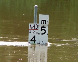 River Heights River Heights
Flood Event Warnings:
For Gympie inundation levels click
here
Click
here
to go to the
WARNINGS PAGE:
Veteran,
Queensland, Australia
Station Details:
ID:
IQUEENSL48
Name: Veteran Lat:
S26 7'37''
Lon: E152 42'8"
Elevation: 157 Metres
Electronically updated at 0:01
on 20/4/24
[ BOM Forecast
is updated @ 5:00am and 5:00pm daily AEST ]
This site is powered 100% by Solar PV & Wind Generation
Cooloola
Severe Weather Gallery
Sign or
View Veteran Weather Station Guest
Book
|

Bureau of Meterology
Click
for Gympie Radar Loop (BOM)
|
|
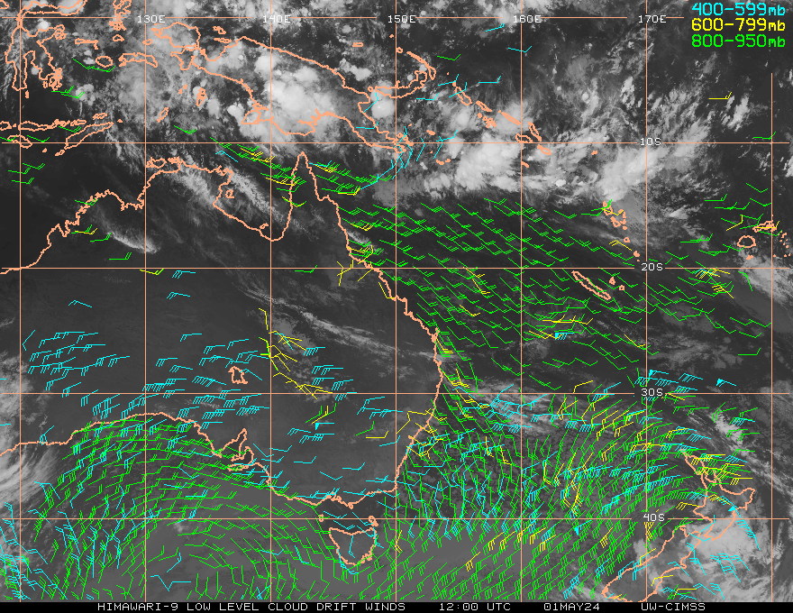
Satellite
Image
(Click on
picture for enhanced satellite image loop)
 |
|
Thunderstorm &
Cyclone Information
(Click on
picture for Thunderstorm & Cyclone details)

|
Veteran Weather Station
Current Lightning
(Click
on the picture for a bigger map and lightning strike information)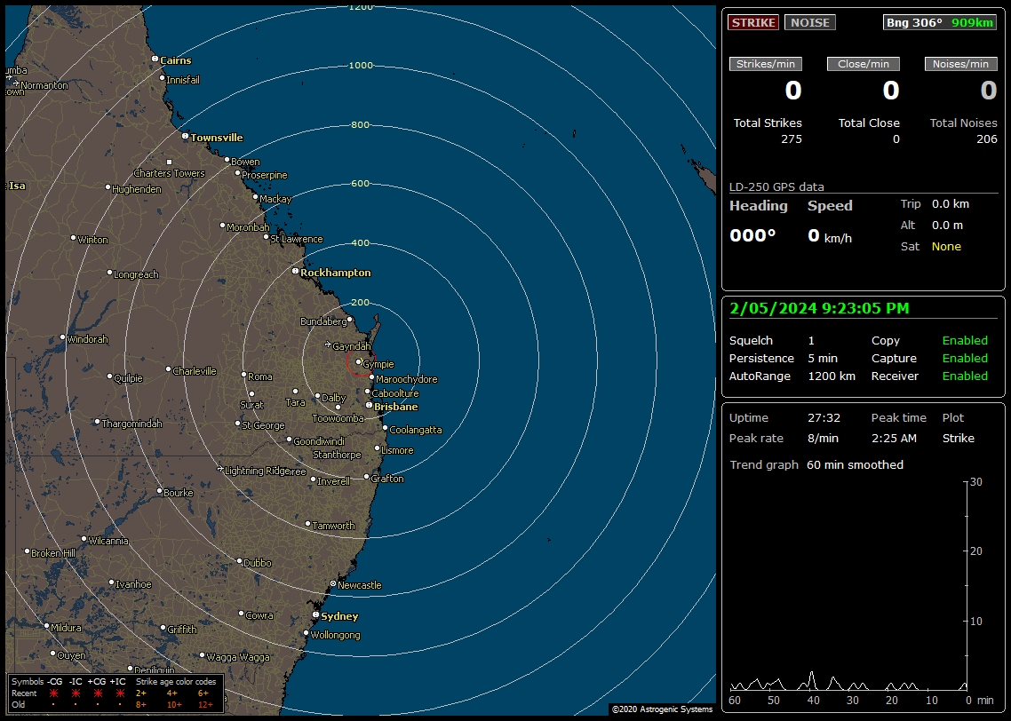 |
|
Veteran
Weather Station Current Conditions
|
Temperature
19.3
@ -0.49 |
Barometer
1017 mb
Falling
@ -0.1 mb |
Humidity
94%
@ 0.0
% |
Avg. Wind
SSE @ 2km
Calm |
Dew Point
18.3 |
Wind Gust
3 km
kn
|
Cloud
Base
135 m
ft
|
Hourly
Rainfall
0.00
mm/hr |
Solar Radiation
0 W/m2
Current UV
0.0 |
Evapotransporation
0.00 mm |
|
Daily
Rainfall
(Rain since 00:00)
0.00
mm |
Annual
Rain
mm
inches
|
|
Sunrise
|
|
|
Sunset
|
|
6:05 |
|
|
17:27 |
|
|

|
|
|
Moonrise
|
|
|
Moonset
|
|
15:31 |
|
|
2:39 |
Current UV
0.0
Today's High
0.0
at
0:00 |
|
Veteran Weather Station Daily
Extremes
|
Temperature
High:19.4 at
0:00
Low:19.3 at
0:00 |
Barometer
High:1017
at 0:00
Low:1017 at 0:00 |
Hygrometer
High:94% at
0:00
Low:94% at
0:00 |
Wind Gust
3km
knots
at 0:00
|
Rain
Rate
0.000mm
inches at0:00 |
Monthly Rain
Rainfall for this Month
36.83
mm |
Gympie Weather

Promote your Page too
|
|
|
|
|
GYMPIE and REGION:
IDQ10240
Australian Government Bureau of Meteorology
Queensland

Updated Wide Bay and Burnett District Forecast
Issued at 10:52 pm EST on Friday 19 April 2024
for the period until midnight EST Tuesday 23 April 2024.

Warning Information
For latest warnings go to www.bom.gov.au, subscribe to RSS feeds, call 1300 659
210* or listen for warnings on relevant TV and radio broadcasts.

Weather Situation
A trough extends over the far northern Peninsula and Gulf of Carpentaria with a
weak embedded tropical low located over the far northern waters. The tropical
low will drift westward into the Arafura Sea over the weekend, weakening the
trough and easing the shower activity across Far North Queensland. A large high
pressure system moving east over the Great Australian Bight, will strengthen a
ridge across the west and north of the state over the next few days. A
significant upper low and trough may enhance rainfall for parts of southeastern
and central Queensland over the weekend and into early next week. A low
pressure system may also form off the east coast later in the weekend because
of this upper feature, and lead to increasing wind and swells along parts of
the central and southern Queensland coast.

Forecast for the rest of Friday 19 April
Partly cloudy. Slight chance of a shower. Light winds.

Forecast for Saturday 20 April
Cloudy. Very high chance of rain, most likely from the late morning. The chance
of a thunderstorm in the north. Heavy falls possible inland. Light winds
becoming southeasterly 15 to 25 km/h in the morning then tending southerly 15
to 20 km/h in the late evening. Overnight temperatures falling to between 13
and 19 with daytime temperatures reaching 20 to 25.

Bundaberg           Rain.                           Min 19      Max 25
Gayndah             Rain.                           Min 17      Max 23
Gympie              Rain.                           Min 17      Max 23
Hervey Bay          Rain.                           Min 20      Max 25
Kingaroy            Rain.                           Min 13      Max 20
Maryborough         Rain.                           Min 18      Max 24

Fire Danger:
No Rating

Sun protection 8:50am to 2:40pm, UV Index predicted to reach 7 [High]

Forecast for Sunday 21 April
Cloudy. Very high chance of rain. The chance of a thunderstorm. Winds southerly
15 to 20 km/h turning southeasterly 20 to 30 km/h during the morning. Overnight
temperatures falling to between 12 and 17 with daytime temperatures reaching
between 19 and 23.

Bundaberg           Showers.                        Min 17      Max 23
Gayndah             Rain.                           Min 16      Max 22
Gympie              Rain.                           Min 16      Max 22
Hervey Bay          Rain.                           Min 18      Max 25
Kingaroy            Rain.                           Min 13      Max 19
Maryborough         Rain.                           Min 17      Max 23

Forecast for Monday 22 April
Partly cloudy. Very high chance of showers near the coast, medium chance
elsewhere. The chance of a thunderstorm about K'gari. Winds southeasterly 25 to
35 km/h. Overnight temperatures falling to between 14 and 18 with daytime
temperatures reaching the low to mid 20s.
Large and powerful surf conditions are expected to be hazardous for coastal
activities such as rock fishing, swimming and surfing.

Bundaberg           Showers. Becoming windy.        Min 18      Max 25
Gayndah             Partly cloudy.                  Min 17      Max 25
Gympie              Showers.                        Min 17      Max 24
Hervey Bay          Showers. Becoming windy.        Min 19      Max 25
Kingaroy            Possible shower.                Min 14      Max 22
Maryborough         Showers.                        Min 18      Max 24

Forecast for Tuesday 23 April
Partly cloudy. Medium chance of showers along the coastal fringe, slight chance
elsewhere. Winds southeasterly 25 to 35 km/h becoming light during the evening.
Overnight temperatures falling to between 13 and 19 with daytime temperatures
reaching the low to mid 20s.
Large and powerful surf conditions in the early morning are expected to be
hazardous for coastal activities such as rock fishing, swimming and surfing.

Bundaberg           Partly cloudy.                  Min 19      Max 26
Gayndah             Partly cloudy.                  Min 17      Max 26
Gympie              Shower or two.                  Min 18      Max 25
Hervey Bay          Shower or two.                  Min 19      Max 26
Kingaroy            Partly cloudy.                  Min 14      Max 23
Maryborough         Shower or two.                  Min 19      Max 26

The next routine forecast will be issued at 5:00 am EST Saturday.

* Calls to 1300 numbers cost around 27.5c incl. GST, higher from mobiles or
public phones.


Copyright Commonwealth of Australia 2011, Bureau of Meteorology (ABN 92 637 533
532).  Users of these web pages are deemed to have read and accepted the
conditions described in the Copyright, Disclaimer, and Privacy statements
(http://www.bom.gov.au/other/copyright.shtml).
|
STATE FORECAST:
IDQ10700
Australian Government Bureau of Meteorology
Queensland

Queensland State Forecast
Issued at 4:30 pm EST on Friday 19 April 2024
for the period until midnight EST Friday 26 April 2024.

Warning Information
For latest warnings go to www.bom.gov.au, subscribe to RSS feeds, call 1300 659
210* or listen for warnings on relevant TV and radio broadcasts.

Weather Situation
A trough extends over the far northern Peninsula and Gulf of Carpentaria with a
weak embedded tropical low located over the far northern waters. The tropical
low will drift westward into the Arafura Sea over the weekend, weakening the
trough and easing the shower activity across Far North Queensland. A large high
pressure system moving east over the Great Australian Bight, will strengthen a
ridge across the west and north of the state over the next few days. A
significant upper low and trough may enhance rainfall for parts of southeastern
and central Queensland over the weekend and into early next week. A low
pressure system may also form off the east coast later in the weekend because
of this upper feature, and lead to increasing wind and swells along parts of
the central and southern Queensland coast.

Forecast for the rest of Friday 19 April
Isolated showers in eastern districts, tending scattered to widespread with
localised moderate falls possible about the northeast tropical coast north of
Port Douglas. The chance of a thunderstorm in Far North Queensland north of
Cairns. Mostly clear in western and southern interior Queensland. Light to
moderate northeast to southeast winds, tending south to southeasterly about the
southwest of the state.

Forecast for Saturday 20 April
Isolated to scattered showers about the tropical east coast and adjacent
inland, tending widespread with a risk of localised moderate falls about the
northern Peninsula. Cloudy with scattered to widespread showers and areas of
rain developing over parts of central and southeastern Queensland south of
about St Lawrence, with some moderate rainfall accumulations possible. The
chance of thunderstorms over the Peninsula and in eastern districts between
Hervey Bay and St Lawrence. Mostly sunny in western Queensland, partly cloudy
in the southern interior with the chance of showers near the New South Wales
Border. The chance of early morning fog inland in southeastern and central
Queensland. Light to moderate south to southeasterly winds, fresh at times
about east coast south of Mackay and near the southern Gulf coast. Maximum
temperatures below or well below average in the western, central and southern
parts, near average elsewhere.

Fire Danger:
High for the Gulf Country, North West and Channel Country districts.

Forecast for Sunday 21 April
Isolated showers about the tropical east coast tending scattered about the
northern Cape York Peninsula and Torres Strait. Cloudy with scattered to
widespread showers and areas of rain over parts of central and southeast
Queensland south of Rockhampton, with some moderate falls possible. However,
uncertainty in amounts and focus as dependent on trough and low development and
movement. The chance of thunderstorms over the Peninsula and in southeastern
and central Queensland south of St Lawrence. Mostly sunny in western
Queensland, partly cloudy elsewhere. Strong and gusty southeasterly winds about
the east coast south of Yeppoon. Hazardous surf conditions possible about the
central and southeast coast south of Agnes Waters later in the day. Maximum
temperatures below or well below average in western, central and southern
parts, near average elsewhere. Minimums below average about the west and
interior.

Forecast for Monday 22 April
Partly cloudy with isolated showers in eastern districts along with over the
central inland, tending scattered about the far northern Peninsula and Torres
Strait. Scattered to widespread showers about coastal parts of central and
southeast Queensland south of St Lawrence. Mostly sunny in western, central and
southern interior Queensland. Strong and gusty southeasterly winds about the
east coast south of Yeppoon. Hazardous surf conditions possible about the
central and southeast coast south of Agnes Waters. Maximum temperatures below
average across western, central and southern parts, near average elsewhere.
Minimums below average about the tropical east coast, northern interior and
northwest.

Forecast for Tuesday 23 April
Partly cloudy with isolated showers in eastern districts, tending scattered
with the chance of a thunderstorm in the far northern Peninsula and Torres
Strait. Scattered showers in southeast Queensland, possibly tending widespread
at times about the Sunshine Coast. Mostly sunny in western, and interior
Queensland. Fresh to strong southeasterly winds about the exposed east coast
south of Yeppoon. Hazardous surf conditions possible about the southern
Queensland coast south of Sandy Cape. Maximum temperatures a little below
average across northwestern, central and southeastern parts, near average
elsewhere.

Outlook for Wednesday 24 April to Friday 26 April
Partly cloudy in eastern districts with isolated showers near the coast and in
Far North Queensland, tending scattered over Torres Strait. Isolated to
scattered showers in southeast Queensland. Mostly sunny in western and interior
Queensland. Fresh southeasterly winds about the exposed east coast south of
Yeppoon, easing after Wednesday. Maximum temperatures tending below average in
the west and southern interior, near average elsewhere.

The next routine forecast will be issued at 4:30 am EST Saturday.

* Calls to 1300 numbers cost around 27.5c incl. GST, higher from mobiles or
public phones.


Copyright Commonwealth of Australia 2011, Bureau of Meteorology (ABN 92 637 533
532).  Users of these web pages are deemed to have read and accepted the
conditions described in the Copyright, Disclaimer, and Privacy statements
(http://www.bom.gov.au/other/copyright.shtml).
|
|
|
Ted's Comment... Thursday, 21 March 2024 10:26
I have updated some important links, remember to have a look at the links on
the left of the page to see what is going on in our region...
Ted
Uebergang |
|
|
|
|
|
|
|
|
|
|

|

|

|

|

|

|
 |
 |
 |
|
|
|
|
